
Simon Truby Cashes In on the Good Earth
How can you make a quick buck? Definitely not through farming! Farming requires dedication, resilience, and patience. But property sales could turn a pretty profit with relative ease in the late 1800s in Apollo, PA.
If you were Simon Truby’s farmhand in 1880, you’d have to work plenty hard to help him raise a cool $225. You’d help him pick the 300 bushels of apples and peaches his farm produced that year, which could bring in about 35 cents a bushel, or $105 total. And you’d help sow and reap his 350 bushels of oats to earn just over $120 in sales. That $225 profit would quickly dwindle away, though, when you consider the associated costs of farm upkeep, such as mending fences, plowing, irrigation, paying laborers, etc. A tough life!
On the other hand, Simon Truby found that he could rake in about $200 for selling just over one-tenth of an acre of land in Apollo, or a plot of about 4,800 square feet. And Simon had plenty of land—156 acres to be exact. Demand for that land grew considerably throughout the second half of the 19th century, as Apollo’s businesses and industries continued to expand.
Land records show that Simon Truby sold more than 50 residential lots in today’s Apollo and North Apollo during his lifetime. Most of these lots were along today’s North 6th and North 7th streets. Some were in Pegtown, next to the Kiski River a little north of Apollo. Strangely enough, nearly one-third of Simon’s real estate sales were to women—including widows—which seems somewhat unusual for that time.
After Simon’s death, of course, his entire farm would be divvied up into hundreds of residential lots. But for the moment, let’s keep the focus on the land Simon himself sold between the 1860s and his death in 1886.
Apollo Expands to Include Truby Farm’s Lower Corner
In the early days, Simon Truby’s farm was located to the north of the town of Apollo/Warren, in what was then called Kiskiminitas Township, and his land was mostly uninhabited. But the successes of industries along the Kiski River changed all that. Growing businesses like the iron rolling mill needed a local labor force. So the tiny borough of Apollo decided to extend its purview over neighboring lands to the north.
With the stroke of a pen—and additional legislative paperwork—Apollo borough more than doubled its size in 1859, growing from about 60 acres (yellow in the map below) to approximately 130 acres under the Act of March 31, 1859 (P.L. 328). Under this Act, the annexation of Apollo borough not only included the iron rolling mill; it also extended significantly into Simon Truby’s farmland, including his brick house that still stands on today’s Terrace Ave in Apollo (see map below).

Follow the River. Why did the borough extend its boundaries to the north instead of stretching further inland, to the east? Successful industries like the nail factory and rolling mill—and later the steel mill—needed to be situated next to the Kiskiminitas River, which provided energy and also helped to transport goods. Apollo borough surely wanted a piece of that industrial action and tax base! So the borough’s boundaries expanded northward and kept to the Kiski River.
Besides taking in a corner of Simon Truby’s farm, the 1859 addition to Apollo borough also included land owned by James Guthrie, and some vested in John B. Chambers.
Three regional history books mention the new plots of land laid out by Truby, Chambers, Guthrie, and others in Apollo borough: T J Henry’s History of Apollo, Pennsylvania (1916, page 25); J H Beers’s Armstrong County, Pennsylvania, Her People Past and Present (1914, chapter 15); and R W Smith’s History of Armstrong County, Pennsylvania (1883, page 241).
Only the oldest of these books—Smith’s history—goes into enough detail to outline the boundaries of the Truby, Chambers, and Guthrie properties that were divided into residential lots. Since Apollo’s street names have changed since 1883, I’ve included the current street names in brackets:
“A considerable portion of the territory annexed to the borough by the act of March 31, 1859, became vested in John B. Chambers, who caused forty-five building, or in-lots, and twenty-one out-lots, to be surveyed and laid out, December 4, 1865. The portion of Canal Street [Warren Ave] in this plot is thirty-three feet wide, and those portions of Church, Locust, Wood, State, and Union streets [Pennsylvania, Armstrong, and Terrace avenues, North 5th and N 4th streets] within it are, respectively, forty feet wide.
Adjoining and above this plot, extending to the alley between and parallel to Mill and Maple streets [N 2nd and N 3rd streets], and between Church and Canal streets [Pennsylvania and Warren avenues], is a smaller plot, laid out about the same time by James Guthrie, and below and adjoining it i.e., the Chambers plot, is another plot more recently laid out by Simon Truby, through which extend, nearly east and west, First and Second streets [N 6th and N 7th streets].”
—From Smith’s History of Armstrong County, Pennsylvania, page 241.
Based on Smith’s description, and a look at land deeds as well, we can outline the properties laid out by Truby, Guthrie, and Chambers after the 1859 annexation of Apollo:
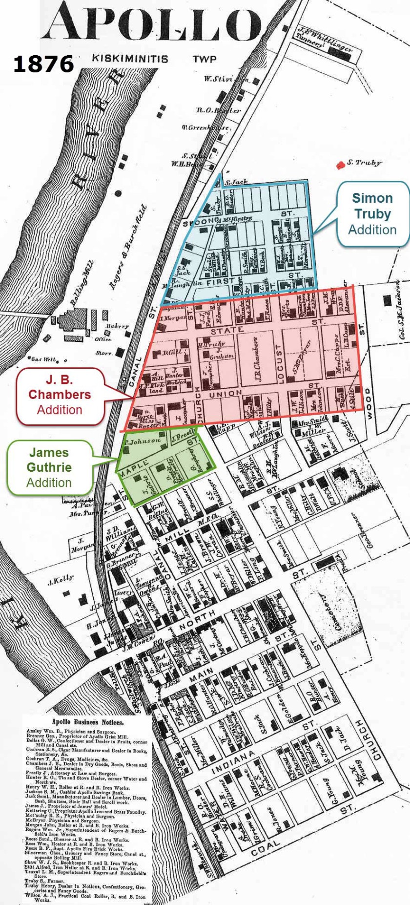
As the map above shows, by 1876, most of these “new” residential or retail lots had already been sold. When the deeds were drawn up, they noted, for example, that a property was “Lot 11 in the Truby Addition to Apollo” (this property is today a vacant lot at the corner of Armstrong & N 6th street); or a deed might note that the property is “Lot 4 in the Chambers Addition to Apollo.” Some deeds call these lots the “Simon Truby Subdivision.” Modern deeds for Apollo properties no longer use this language. But some deeds even as late as the 1970s continued to note which “addition” a property belonged to, and which original landowner had surveyed the lot.
The 1876 map indicates that Simon had already sold more than 20 of his lots by 1876. If these were sold at approximately $200 each, Simon would have more than recouped the original $3,000 he laid out to buy his entire 156-acre property from Dr. James R and Hetty Speer in 1843. That’s a decent return on his investment!
Among the first residential lots Simon sold was lot 34 in the Truby Addition to Apollo Borough, which today is at 404 N 7th Street. In the 1876 map above, this lot is the narrow rectangle labeled “R O Hunter” at the upper edge of the blue-shaded Truby Addition. In 1891, R O Hunter and his wife Margaret sold this property to Oliver Artman. The photo below shows that house today, and the hand-drawn map below shows the house as it appeared in 1896.

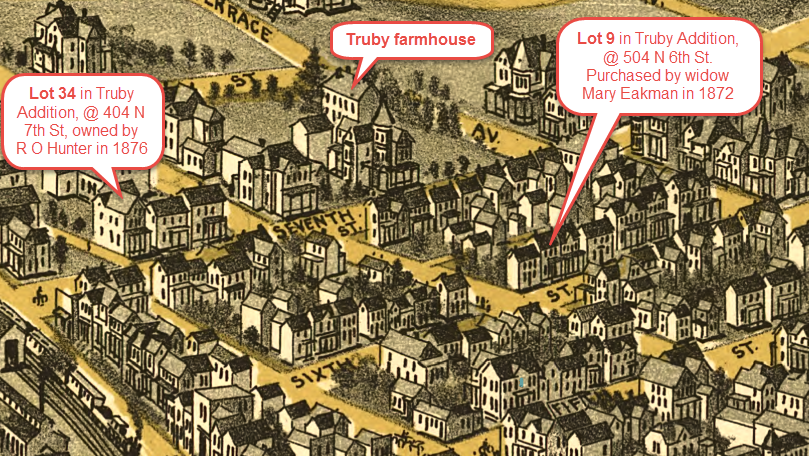
Simon & wife Elizabeth Truby sold Lot 9 in the Truby Addition to 60-year-old widow Mary Eakman on May 28, 1872. More than 30 years later, another widow—Belle Truby Carpenter (Simon Truby’s daughter)—would end up living in this same house, and it would later be inherited by her son Charles Winchester Carpenter and his wife Jesse after Belle’s death in 1927. This property is located at 504 N 6th Street in Apollo (see photo below).

In upcoming blog posts, look for more info about various houses in the Truby Addition to Apollo Borough. And coming soon: Get the scoop on Simon’s brother, Capt Henry Truby of Gilpin Twp near Leechburg.
Subscribe to the Truby Farmhouse blog to receive emails whenever new articles are posted.
Please help to preserve Apollo’s history by becoming a member of the Apollo Area Historical Society at apollopahistory.wordpress.com/become-a-member.
Catch you soon!
-Vicki

fantastic as usual , Vicki. I love each installment you write.
LikeLiked by 1 person
The followers are blessed by your additions. Your hard work is appreciated. As a genealogist with ancestors throughout Vandergrift and Apollo, I appreciate your generosity. Mary Eakman/Eckman is a relation to the Reichenbaugh Family from Vandergrift and Apollo.
LikeLiked by 1 person
Hi Crystal, Thank you for your kind words! I tried to learn a little more about Mary, including the correct spelling of her last name, but came up short. Do you know much more about her? I’d wondered if she was the same Mary Eakman listed in the 1870 census as living with the Samuel Jack family in Apollo, where she was “keeping house.” And I’d wondered if/how she was related to the Jack family. Every piece of info raises new questions! Thanks again for writing.
LikeLike
So interesting, Vicki! I’m really enjoying your blog! I need to get the AAHS one up-dated 🙂
LikeLiked by 1 person